
granpajohn
Minister of Fire
How cold can it be? 4 out of the 5 guys in the photo aren't even wearing a toque.
How cold can it be? 4 out of the 5 guys in the photo aren't even wearing a toque.
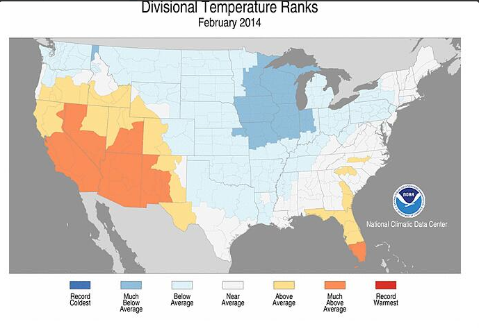 gee, New England temps near ave?(Hartford, Ct.-5.5*).Vegas area +4.7* much above ave? oh well not a bad wintertemp wise, according NOAA.

this mornings discussion from the NWS, noticed they mention a 970mb @ 40n/70w. if it pans out, oh boy?!?http://www.hpc.ncep.noaa.gov/discussions/hpcdiscussions.php?disc=pmdepd


I'm in hanover, se mass. and we do get a lot of backlash from storms like this . might be our turn, but the only place that can always use more are the ski areas.
")

no, no, no there can never be enough. don't you want to ski til july?!?


It's been a cold winter up here in NW Wisconsin. Last night and the next 3 nights will still be below zero. Looking forward to a May thaw unlike last years winter storms!gee, New England temps near ave?(Hartford, Ct.-5.5*).Vegas area +4.7* much above ave? oh well not a bad wintertemp wise, according NOAA.
records back as long we've had records will fall here but not the cold you get. slow start for a lot of the nation to the warm of spring. 37-38* water 10 mi. for my town means a long time to warm up.It's been a cold winter up here in NW Wisconsin. Last night and the next 3 nights will still be below zero. Looking forward to a May thaw unlike last years winter storms!
I'm not sure if it effects us here but Lake Superior is just 50 miles north.records back as long we've had records will fall here but not the cold you get. slow start for a lot of the nation to the warm of spring. 37-38* water 10 mi. for my town means a long time to warm up.
when it blows from n-nw, you must get lake snow?I'm not sure if it effects us here but Lake Superior is just 50 miles north.
No, that starts to happen about 50 miles to the NE. I am in Winter, WI if you look up geography.when it blows from n-nw, you must get lake snow?
luckey, used to a lot of business in your state with shoe ,red wing, weyenbriener, amoung others. and of course Wisconsin has the only town in America that sounds like a fart in a bath tub, Beloit?No, that starts to happen about 50 miles to the NE. I am in Winter, WI if you look up geography.
! no offense meant, have a day

