
Wisconsin Weather Update....THIS SUCKS!!!!
- Thread starter krooser
- Start date
-
Active since 1995, Hearth.com is THE place on the internet for free information and advice about wood stoves, pellet stoves and other energy saving equipment.
We strive to provide opinions, articles, discussions and history related to Hearth Products and in a more general sense, energy issues.
We promote the EFFICIENT, RESPONSIBLE, CLEAN and SAFE use of all fuels, whether renewable or fossil.
You are using an out of date browser. It may not display this or other websites correctly.
You should upgrade or use an alternative browser.
You should upgrade or use an alternative browser.
- Status
- Not open for further replies.
mjbrown
Feeling the Heat
we're expected to get it aroud late morning here...they say 8-12" before its over with a change to sleet and freezing rain at the end. should make for an interesting ride home tonite! 16* at 4 am this morning.
jtakeman
Minister of Fire
5:00 AM here we had close to 3 inches. But they only perdicted 5" total Bet they missed it again. But the kid is happy. NO SCHOOL!
Hey krooser, Can you turn that fan off PLEASE. :lol:
Now back to the news.
Hey krooser, Can you turn that fan off PLEASE. :lol:
Now back to the news.
jtp10181
Minister of Fire
S
smoke show
Guest
hey krooser could be 16" by the time its over.
off to work for me.
http://weather.weatherbug.com/WI/Pulaski-weather/local-forecast/detailed-forecast.html?zcode=z6286
off to work for me.
http://weather.weatherbug.com/WI/Pulaski-weather/local-forecast/detailed-forecast.html?zcode=z6286
SmokeyTheBear
Minister of Fire
It started a bit after 7:00 AM here and my chickens are really really mad at me. I didn't open the coop door and let them out.
krooser, please aim that fan towards Florida, got to share this white stuff with the vacationing woolly bears.
krooser, please aim that fan towards Florida, got to share this white stuff with the vacationing woolly bears.
jamesdjs
Member
9:30 am and we have about 6-8 inches already in the Berkshires. Winds are picking up blowing the snow every where.
Suppose to turn to freezing rain this afternoon. Thanks going to suck.
Suppose to turn to freezing rain this afternoon. Thanks going to suck.
Xena
Minister of Fire
We got a couple inches and now it's going to pour rain all day.
Icky mess and no plowing out of it.
Icky mess and no plowing out of it.
gbreda
Minister of Fire
Started at 6AM here, snowing heavy since. 6-10" then supposed to change over later this afternoon. Hey, it's almost winter in New England.
At work right now, but I got my Ice Pellet bucket out at home. Yesterday's hour by hour forecast showed them to be dropping between 1 and 3 this afternoon. Gonna burn them babies tonight !!
!!
At work right now, but I got my Ice Pellet bucket out at home. Yesterday's hour by hour forecast showed them to be dropping between 1 and 3 this afternoon. Gonna burn them babies tonight
!!JustWood
Minister of Fire
We're supposed to get 30" by Friday. I'm not 100% ready but close. Oh well ,such is life in the weather butthole of North America.
mattson70
New Member
We had 6 inches in South Dakota and a balmy high of 5 degrees with 20mph winds. Low of -10 degrees tonight. Ridunkulous.
I
imacman
Guest
mattson70 said:We had 6 inches in South Dakota and a balmy high of 5 degrees with 20mph winds. Low of -10 degrees tonight. Ridunkulous.
Can anyone say "Thanks Al Gore"?
jtakeman
Minister of Fire
mattson70
New Member
Yeah, I'd like Al Gore to come visit North or South Dakota in late January or early February and just feel how warm the Earth is. Hopefully the battery on his Prius would freeze.
I
imacman
Guest
mattson70 said:Yeah, I'd like Al Gore to come visit North or South Dakota in late January or early February and just feel how warm the Earth is. Hopefully the battery on his Prius would freeze.
Easy, easy there guys.....you might offend Krooser, the OP of this thread.....he's a BIG fan of Al boy (not). He waves to Al every time Al flies over his house in his big Gulfstream II private jet spewing tons of carbon into the air....oh, wait a minute.....Al asked "Can you say "carbon credits" ?
hossthehermit
Minister of Fire
woodsman23
Minister of Fire
This is just beginning....
NYZ019-020-100500- /O.UPG.KBUF.WS.A.0005.091210T0000Z-091212T0000Z/ /O.NEW.KBUF.LE.W.0010.091210T0900Z-091212T1200Z/ CHAUTAUQUA-CATTARAUGUS- INCLUDING THE CITIES OF... JAMESTOWN... OLEAN 349 PM EST WED DEC 9 2009 ... LAKE EFFECT SNOW WARNING IN EFFECT FROM 4 AM THURSDAY TO 7 AM EST SATURDAY...
THE NATIONAL WEATHER SERVICE IN BUFFALO HAS ISSUED A LAKE EFFECT SNOW WARNING... WHICH IS IN EFFECT FROM 4 AM THURSDAY TO 7 AM EST SATURDAY. THE WINTER STORM WATCH IS NO LONGER IN EFFECT.
LAKE EFFECT SNOW IS EXPECTED TO DEVELOP OVER LAKE ERIE BY LATE THIS EVENING THEN MOVE INLAND INTO WESTERN CHAUTAUQUA AND EXTREME NORTHWEST CATTARAUGUS COUNTIES LATE TONIGHT THROUGH THURSDAY.
PERIODS OF LAKE EFFECT SNOW WILL CONTINUE FROM THURSDAY NIGHT THROUGH FRIDAY NIGHT... MAINLY ACROSS THE NORTHERN AND WESTERN SECTIONS OF CHAUTAUQUA COUNTY AND THE NORTHERN HALF OF CATTARAUGUS COUNTY.
SNOWFALL RATES OF 2 TO 4 INCHES PER HOUR ARE LIKELY IN THE MOST INTENSE PORTION OF THIS BAND. IN ADDITION TO HEAVY SNOWFALL...
STRONG WINDS WILL CREATE BLIZZARD CONDITIONS AT TIMES WITH NEAR ZERO VISIBILITY IN SIGNIFICANT TO SEVERE BLOWING AND DRIFTING SNOW AND TRAVEL IMPOSSIBLE ON MOST ROADS.
EXPECT STORM TOTALS OF 3 TO 5 FEET BY SATURDAY MORNING WHERE LAKE EFFECT SNOW PERSISTS THE LONGEST.
I so want to move right now.....
SmokeyTheBear
Minister of Fire
woodsman23 said:This is just beginning....
NYZ019-020-100500- /O.UPG.KBUF.WS.A.0005.091210T0000Z-091212T0000Z/ /O.NEW.KBUF.LE.W.0010.091210T0900Z-091212T1200Z/ CHAUTAUQUA-CATTARAUGUS- INCLUDING THE CITIES OF... JAMESTOWN... OLEAN 349 PM EST WED DEC 9 2009 ... LAKE EFFECT SNOW WARNING IN EFFECT FROM 4 AM THURSDAY TO 7 AM EST SATURDAY...
THE NATIONAL WEATHER SERVICE IN BUFFALO HAS ISSUED A LAKE EFFECT SNOW WARNING... WHICH IS IN EFFECT FROM 4 AM THURSDAY TO 7 AM EST SATURDAY. THE WINTER STORM WATCH IS NO LONGER IN EFFECT.
LAKE EFFECT SNOW IS EXPECTED TO DEVELOP OVER LAKE ERIE BY LATE THIS EVENING THEN MOVE INLAND INTO WESTERN CHAUTAUQUA AND EXTREME NORTHWEST CATTARAUGUS COUNTIES LATE TONIGHT THROUGH THURSDAY.
PERIODS OF LAKE EFFECT SNOW WILL CONTINUE FROM THURSDAY NIGHT THROUGH FRIDAY NIGHT... MAINLY ACROSS THE NORTHERN AND WESTERN SECTIONS OF CHAUTAUQUA COUNTY AND THE NORTHERN HALF OF CATTARAUGUS COUNTY.
SNOWFALL RATES OF 2 TO 4 INCHES PER HOUR ARE LIKELY IN THE MOST INTENSE PORTION OF THIS BAND. IN ADDITION TO HEAVY SNOWFALL...
STRONG WINDS WILL CREATE BLIZZARD CONDITIONS AT TIMES WITH NEAR ZERO VISIBILITY IN SIGNIFICANT TO SEVERE BLOWING AND DRIFTING SNOW AND TRAVEL IMPOSSIBLE ON MOST ROADS.
EXPECT STORM TOTALS OF 3 TO 5 FEET BY SATURDAY MORNING WHERE LAKE EFFECT SNOW PERSISTS THE LONGEST.
I so want to move right now.....
Gee this sounds like you'll need an additional 20' added to your vent system. Look on the bright side after you get the house completely covered it will be well insulated. Perhaps you can claim the snow as an energy savings tax credit when you file those little guvmint tax forms.
trogers
New Member
I
imacman
Guest
woodsman23 said:This is just beginning....
......EXPECT STORM TOTALS OF 3 TO 5 FEET BY SATURDAY MORNING WHERE LAKE EFFECT SNOW PERSISTS THE LONGEST.
I so want to move right now.....
I don't blame you.
ROBERT F
Minister of Fire
Well this nice system yall are gettin right now just left Colorado, and we are still fightin off the 40 mph wind gusts and the negitive high temps with super low negitive wind chills. Yep, you guessed it, I actually gave in and fired the propane boiler up. But it'll get shut down again in about 2 days.
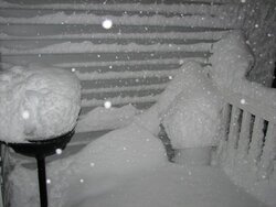
We wound up with 16" overnight... the old Cub Cadet blower got a real workout ... the snow was real heavy and wet... reminds me of an old girlfriend...
packerfan
Feeling the Heat
86 toy
Member
krooser said:... the snow was real heavy and wet... reminds me of an old girlfriend...
:lol: thats funny right there
!jtp10181
Minister of Fire
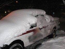
packerfan said:here is what I found in my driveway this morning, I didn't even see it until I turned the corner in my driveway.
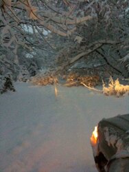
There were branches down all over in downtown mad today. I wish I would have taken some pictures but I was in "work mode" and not thinking about it at the time. Was crazy looking down there, snowed in cars, branches all over, people wondering around in the street everywhere. I parked in a snow bank between two branches in front of a meter... thought for a second about putting some quarters in then looked around again, no way parking enforcement was going to be driving around.
I had to go do a preview for a new fireplace at an all girls sorority house
")
Wasn't going to miss that one just cause of a little snow.
- Status
- Not open for further replies.
Similar threads
- Replies
- 14
- Views
- 2K
- Replies
- 24
- Views
- 3K
- Replies
- 50
- Views
- 2K
- Replies
- 0
- Views
- 498