
Interesting Reading for those that Like this stuff ")
2007-2008 Weather Outlook for the U.S.
Click here for the 2007-2008 Canadian Outlook »
Farmers' Almanac Rleases a Two-Faced or Split Personality Weather Forecast
“Mother Nature is once again keeping all of us on our toes,” reveals Editor and Philom.,Peter Geiger, “ we know she likes to throw curve balls at us from time to time and this winter it looks as though she’s going to reveal a possible split personality.”
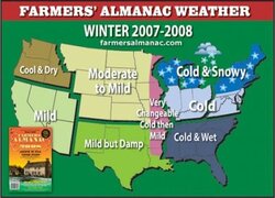
The 2008 Farmers’ Almanac long-range forecasts are calling for colder than normal conditions for the eastern half of the country – chiefly those areas east of the Mississippi –with snowier than normal conditions expected.
For the western half of the country - mainly those areas west of the Mississippi – the overall winter will be milder than normal, with near or below normal precipitation. Quite a change from last year, when cold and stormy weather came blasting.
“This is not to say that there won’t be any snow in the North Central region,” shares Geiger, “but we do feel that overall Mother Nature is showing no mercy to the east and being a little more forgiving in the west.”
The 2008 Farmers’ Almanac predicts that skiers in eastern New York and New England will enjoy some great conditions (click here for our skiing outlook). The winter should also average as much as three degrees below normal down most of the Atlantic Coast, from New England through the Mid-Atlantic and the Piedmont into the Southeast. Cold conditions are on tap for the Southeast, with at least four cold frosts predicted all the way to Florida.
Cold and snowy weather should also prevail over the Great Lakes region. Even as far south as the central and eastern Gulf Coast, unseasonably chilly temperatures will prevail. In contrast, the Great Plains, the Rocky Mountains, the Southwest desert, and the Pacific Coast should enjoy a relatively mild and somewhat drier than normal winter overall. For some locations, the amount of wintertime precipitation – rain or snow – could average from one quarter to as much as one half below the seasonal norm. Quite a contrast to last year.
And near and along the boundary zone between the mild, tranquil West and the cold, stormy East, we look for some large-scale weather vacillations: from wintry to spring like and back to wintry, almost like a meteorological pendulum undergoing a series of pretty wild swings.
THE REST OF THE YEAR . . .
Spring looks cool and somewhat wet for many areas. Across Tornado Alley in the nation’s heartland, 2008 should be an unusually active season.
Summer will be uniformly warmer than normal across much of the nation. Precipitation will average near or somewhat below normal, except over much of the central U.S. where higher than normal rainfall will occur. Parts of the Midwest and the Mid-Atlantic in particular will see occasional bouts of very heavy rainfall, from heavy showery rains and locally strong thunderstorms, and in part generated by tropical activity (see below). Heavier than normal rainfall may also fall over some of the Plains and Rockies. In contrast, we are forecasting much lower than normal precipitation amounts along the Pacific Coast. Cooler and drier weather should take hold during the fall, followed by a spell of cold and unsettled conditions in November and December.
We expect an active tropical season in 2008, with the Gulf Coast directly in the crosshairs for hurricanes in mid-July, mid-August, and mid-September. The associated tropical moisture from such systems is likely to flow northward, creating a threat of excessive rainfall over many eastern locations. The traditional peak of the hurricane season occurs on September 10.
2007-2008 Weather Outlook for the U.S.
Click here for the 2007-2008 Canadian Outlook »
Farmers' Almanac Rleases a Two-Faced or Split Personality Weather Forecast
“Mother Nature is once again keeping all of us on our toes,” reveals Editor and Philom.,Peter Geiger, “ we know she likes to throw curve balls at us from time to time and this winter it looks as though she’s going to reveal a possible split personality.”
The 2008 Farmers’ Almanac long-range forecasts are calling for colder than normal conditions for the eastern half of the country – chiefly those areas east of the Mississippi –with snowier than normal conditions expected.
For the western half of the country - mainly those areas west of the Mississippi – the overall winter will be milder than normal, with near or below normal precipitation. Quite a change from last year, when cold and stormy weather came blasting.
“This is not to say that there won’t be any snow in the North Central region,” shares Geiger, “but we do feel that overall Mother Nature is showing no mercy to the east and being a little more forgiving in the west.”
The 2008 Farmers’ Almanac predicts that skiers in eastern New York and New England will enjoy some great conditions (click here for our skiing outlook). The winter should also average as much as three degrees below normal down most of the Atlantic Coast, from New England through the Mid-Atlantic and the Piedmont into the Southeast. Cold conditions are on tap for the Southeast, with at least four cold frosts predicted all the way to Florida.
Cold and snowy weather should also prevail over the Great Lakes region. Even as far south as the central and eastern Gulf Coast, unseasonably chilly temperatures will prevail. In contrast, the Great Plains, the Rocky Mountains, the Southwest desert, and the Pacific Coast should enjoy a relatively mild and somewhat drier than normal winter overall. For some locations, the amount of wintertime precipitation – rain or snow – could average from one quarter to as much as one half below the seasonal norm. Quite a contrast to last year.
And near and along the boundary zone between the mild, tranquil West and the cold, stormy East, we look for some large-scale weather vacillations: from wintry to spring like and back to wintry, almost like a meteorological pendulum undergoing a series of pretty wild swings.
THE REST OF THE YEAR . . .
Spring looks cool and somewhat wet for many areas. Across Tornado Alley in the nation’s heartland, 2008 should be an unusually active season.
Summer will be uniformly warmer than normal across much of the nation. Precipitation will average near or somewhat below normal, except over much of the central U.S. where higher than normal rainfall will occur. Parts of the Midwest and the Mid-Atlantic in particular will see occasional bouts of very heavy rainfall, from heavy showery rains and locally strong thunderstorms, and in part generated by tropical activity (see below). Heavier than normal rainfall may also fall over some of the Plains and Rockies. In contrast, we are forecasting much lower than normal precipitation amounts along the Pacific Coast. Cooler and drier weather should take hold during the fall, followed by a spell of cold and unsettled conditions in November and December.
We expect an active tropical season in 2008, with the Gulf Coast directly in the crosshairs for hurricanes in mid-July, mid-August, and mid-September. The associated tropical moisture from such systems is likely to flow northward, creating a threat of excessive rainfall over many eastern locations. The traditional peak of the hurricane season occurs on September 10.
")