I
ISeeDeadBTUs
Guest
I like winter as much or more as the next guy . . . but this ice, wind, upside down farenheight . . . well, they suck. I say we appoint a new weather person to tell us something better . . .
ISeeDeadBTUs said:I like winter as much or more as the next guy . . . but this ice, wind, upside down farenheight . . . well, they suck. I say we appoint a new weather person to tell us something better . . .
") )
)
firefighterjake said:Keep the snow coming boys . . . I'm loving it . . . barring rain or super warm weather I'll be riding the sled way into March . . . maybe even April
Shari said:In my area -
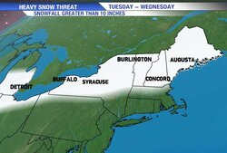
Warning: From the National Weather Service ... BLIZZARD WATCH in effect until Wednesday, Feb 2, 6:00 PM; Additional advisories also in effect more >
muncybob said:All this weather talk got me curious so i checked a few sites and all pretty much agree snow, sleet and ice for the next 2 days or so. I'm gonna check my generator when I get home tonight!
Weathermen, economists and sports casters; good thing their jobs don’t dependant on them being right more than 50% of the time. Wish I could be wrong that often and still keep my job.