
I just returned from W.Virginia helping an old timer harvest his string beans at his farm.A friend introduced us and a few others also went to help.Well I noticed a cord of oak in a shed and the conversation turned to wood burning.He said he was waiting for 4 more cords from some hunters who hunt his land in exchange for firewood.I said that's a good amount of firewood for down here and he told me that it gets down to -15degrees F during the winter that blew my mind.I had no idea it got that cold in the south.It doesn't get that cold in Boston every maybe -5F,So I apologize to the individual who I said out of ignorance that a drafty house in Virginia is not quite the same as a drafty house in Boston.In the hills of W.Virginia it's much more drafty.
I Apologize
- Thread starter Rich L
- Start date
-
Active since 1995, Hearth.com is THE place on the internet for free information and advice about wood stoves, pellet stoves and other energy saving equipment.
We strive to provide opinions, articles, discussions and history related to Hearth Products and in a more general sense, energy issues.
We promote the EFFICIENT, RESPONSIBLE, CLEAN and SAFE use of all fuels, whether renewable or fossil.
You are using an out of date browser. It may not display this or other websites correctly.
You should upgrade or use an alternative browser.
You should upgrade or use an alternative browser.
- Status
- Not open for further replies.
Coldest temp in the state of Virginia, -30 at Moutain Lake on Jan 22, 1985
Coldest temp in the state of Massachusetts, -35 Jan. 12, 1981 at Chester
Coldest temp in the state of West Virginia, -37 Dec. 30, 1917 at Lewisburg
See, it does get colder in Massachusetts than it does in Virginia.
Coldest temp in the state of Massachusetts, -35 Jan. 12, 1981 at Chester
Coldest temp in the state of West Virginia, -37 Dec. 30, 1917 at Lewisburg
See, it does get colder in Massachusetts than it does in Virginia.
Lived in Northern Virginia for 12 years, and I can tell you it gets downright cold there. Even downrighter here in Central Oregon. And remember, when you're talking about "The South", it can mean a lot of things. The Mason-Dixon line wasn't surveyed based on a climatic phenomenon between cold and hot. West Virginia isn't really very far "south". Rick
Altitude helps too. It can get a lot colder at 2-3000 feet than it does at sea level. Boston is tempered by a large bay. Puget Sound does the same for us. But go east 20 miles and you'll be in the Cascade foothills. They often will be snowbound while we are having rain.
Altitude helps too. It can get a lot colder at 2-3000 feet than it does at sea level. Boston is tempered by a large bay. Puget Sound does the same for us. It keeps us cooler in the summer and warmer in the winter. But go east 20 miles and you'll be in the Cascade foothills. They often will be snowbound while we are having rain.
I lived in WV for nine years, still have a house there, Oak Hill. Can get cold, not as cold as Snowshoe but cold. Don
its an altitude thing ...... i am sure if you check "normal" temps throughout winter months mass is a couple degrees colder same as mass to vermont or maine ... they are colder
but hey we all need heat one way or the other ..... so burn on people
but hey we all need heat one way or the other ..... so burn on people
I live in the mountains of West Virginia. Near Canaan Valley, a high elevation (ranging from 3200ft to 4,200 ft) plateau near the Eastern Continental Divide. The ecosystem here is close to that of Canada. Frequently, wind gusts are in the 50-60 mph range--average snowfall is 200-250 inches per year and the temps can often dip into the negative range in the winter. I guess that is why the power company decided to plant 200+ wind turbines here.
We had a high of 62 here today. I also keep my wood covered year round. Canaan (pronounced can-rain) Valley can be a wet place. BTW, you shouldn't apologize for doubting his weather pattern, you should apologize for confusing West Virginia for Virginia (going back in forth between the two in your original post") )
)
We had a high of 62 here today. I also keep my wood covered year round. Canaan (pronounced can-rain) Valley can be a wet place. BTW, you shouldn't apologize for doubting his weather pattern, you should apologize for confusing West Virginia for Virginia (going back in forth between the two in your original post
)Elevation is everything. Wind speed too.
Anything south of CT is "The South". That puts NYC square in the heart of Dixie by my reckoning.
When I have to drive through CT, sometimes it's "The South" as well. Visited Alabama recently on biddnezz and they say "LA" when they mean "Lower Alabama".
Anything south of CT is "The South". That puts NYC square in the heart of Dixie by my reckoning.
When I have to drive through CT, sometimes it's "The South" as well. Visited Alabama recently on biddnezz and they say "LA" when they mean "Lower Alabama".
Adios Pantalones said:Elevation is everything. Wind speed too.
Anything south of CT is "The South". That puts NYC square in the heart of Dixie by my reckoning.
When I have to drive through CT, sometimes it's "The South" as well. Visited Alabama recently on biddnezz and they say "LA" when they mean "Lower Alabama".
LOL. Spoken like a true yankee.
Coldest I remember in the last 25 years here in Northern Virginia was minus 10 back in the '80s. Layed in bed and heard loud popping noises and finally figured out that it was the aluminum gutters contracting. The next day a guy from work came out to find four flat tires on his Maxima. The alloy wheels had shrunk and broken the beads on all four. Da big Sierra wood stove was kickin that night. And we still were sleeping under a pile of blankets.
I have plowed the 800 foot driveway at night when it was three degrees out. I can live without that again. We don't have "real winters" but when we get a taste, it ain't fun.
I have plowed the 800 foot driveway at night when it was three degrees out. I can live without that again. We don't have "real winters" but when we get a taste, it ain't fun.
Well I have had some pines explode in my yard when it got cold. In Maine we tend not to focus on the actual temperature, but rather we KNOW it is cold and then do everything to stay warm.
sinnian said:Well I have had some pines explode in my yard when it got cold.
That'll get your attention. :bug:
The other thing about the ocean in coastal New England is that it has the reverse effect in March - May. It can be calm and 60* where I live, 40 miles inland. In Newport, where the water is still 35-50* it will be 45* and miserably cold. The leaves on the Oaks do not show up for the summer until May 15.
The hills make all the difference in the world on temperature. My elevation is about 1200 feet. The town I live in has an elevation of about 500 feet. I can get up and scrape the windows on my car and leave the snow on it and drive off the hill to town and people look at me like "where did he come from". They didnt get any snow and I got two inches. I can imagine how it would be at 3000 and 4000 where Cannan Valley is. I'm not sure how high Lewisburg is but I've been there and it is up in the hills a bit.
Oh and for you guys who didn't believe how cold it is. Here's another thing people don't believe. We have the best white water rafting in the Country.
Come down here in a month or two, during Gauley season. That's when they drain Summersville dam and we have world class rapids. It's the best rafting in the Country. 2800 cubic feet of water a second. or 1.3 million gallons a minute.
We also have several vineyards that make really good wine.
The UP isn't the coldest place because of the lakes, but it spends a good amount of time below zero (F) some winters and can get 35 below in spots. Back in 93-94 I was at MTU in Houghton, and we went something like 30 straight days with the lows below zero. For about two weeks of that the highs were below zero. Nothing like walking to class at 8AM into 30 MPH gusts at 20 below (wind chill something like 50 below). One of my ears froze stiff under a hockey helmet that year (no frostbite, luckily).
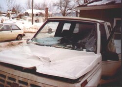
I mostly remember that winter because of all the car problems. I had to change my (now) wife's plugs several times because her car (Tercel) would often flood and foul the plugs after you shut it off in really cold weather. Our house was a big old 3-story with a walkout basement and essentially no insulation in the roof. Normally snow melted off, but that year it was so cold it melted then refroze near the eaves. Come spring a several hundred pound chunk fell 30' or so square onto the hood of my car. Did about $5000 worth of damage. Might have killed me if it had fallen 10 minutes earlier.
I mostly remember that winter because of all the car problems. I had to change my (now) wife's plugs several times because her car (Tercel) would often flood and foul the plugs after you shut it off in really cold weather. Our house was a big old 3-story with a walkout basement and essentially no insulation in the roof. Normally snow melted off, but that year it was so cold it melted then refroze near the eaves. Come spring a several hundred pound chunk fell 30' or so square onto the hood of my car. Did about $5000 worth of damage. Might have killed me if it had fallen 10 minutes earlier.
Attachments
I know some folks have said this in one way or another...
As we learned back in ecology, the walk up a mountain is very much like a walk away from the equator 9depending on where you start of course]. Climate and species composition change dramatically both ways.
Ever climb Mt Washington in the summer/fall. The last time up about 5 years ago, 78 sunny with a mild breeze at the bottom and 41 degrees 40 mph winds at the top.
karl said:Come down here in a month or two, during Gauley season. That's when they drain Summersville dam and we have world class rapids. It's the best rafting in the Country. 2800 cubic feet of water a second. or 1.3 million gallons a minute.
I have done the Upper and Lower Gauley during the fall releases. That river will get and hold your attention. Also did the Upper Youghiogheny. Just ONCE! That thing is a ten mile non-stop train wreck. We lost the guide in the first fifteen minutes.
A point of little interest: West Virgina was formed at the start of the civil war when the people of western Virgina seceded from the state of Virgina because of their allegiance to the North.
karl said:Come down here in a month or two, during Gauley season. That's when they drain Summersville dam and we have world class rapids. It's the best rafting in the Country. 2800 cubic feet of water a second. or 1.3 million gallons a minute.
Shoot, they release around 4000 cfs out of Harris Dam into the Kennebec river daily. If you really want a ride, go on one of their high release days and you can find out what 8000 cfs is like!
karl said:Oh and for you guys who didn't believe how cold it is. Here's another thing people don't believe. We have the best white water rafting in the Country.
Come down here in a month or two, during Gauley season. That's when they drain Summersville dam and we have world class rapids. It's the best rafting in the Country. 2800 cubic feet of water a second. or 1.3 million gallons a minute.
Been there and done that a couple of times. Awesome rafting. Technically, second in the country to the Colorado, I believe.
Pete
- Status
- Not open for further replies.
Similar threads
- Replies
- 11
- Views
- 2K
- Replies
- 10
- Views
- 2K
- Replies
- 78
- Views
- 11K