3rd Damaged Sugar Maple

  • Active since 1995, Hearth.com is THE place on the internet for free information and advice about wood stoves, pellet stoves and other energy saving equipment.

    We strive to provide opinions, articles, discussions and history related to Hearth Products and in a more general sense, energy issues.

    We promote the EFFICIENT, RESPONSIBLE, CLEAN and SAFE use of all fuels, whether renewable or fossil.
Status
Not open for further replies.

thewoodlands

Minister of Fire
Aug 25, 2009
16,667
In The Woods
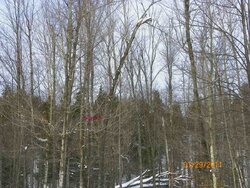
When I was heading down the hill I noticed this damaged Sugar Maple right off the trail so I decided to come back and take it.

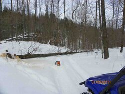
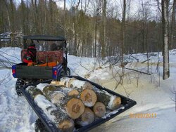
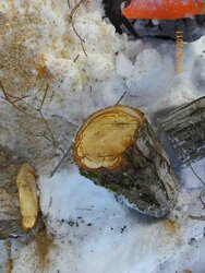
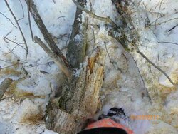
Picture 2564 is the damaged Sugar Maple, 2568 is after the fell,2569 is loaded up and coming home and the last two are the top that was rotting.


Zap
 

Attachments

  • 100_2564.jpg
    100_2564.jpg
    145.6 KB · Views: 310
  • 100_2568.jpg
    100_2568.jpg
    76.8 KB · Views: 306
  • 100_2569.jpg
    100_2569.jpg
    93 KB · Views: 298
  • 100_2570-2.jpg
    100_2570-2.jpg
    49.4 KB · Views: 304
  • 100_2571-2.jpg
    100_2571-2.jpg
    61 KB · Views: 310
loon said:
great day zap ;-P

loon

Loon, I'll take more days like that. I have two maybe three more Sugar Maple in that area that are damaged so hopefully Sunday I'll get back in and grab them.


Zap
 
did more work today on the tractor than cut wood :shut: but did get some done late this afternoon zap :cheese:

DSC09428.jpg
 
[quote author="loon" date="1296360504"]did more work today on the tractor than cut wood :shut: but did get some done late this afternoon zap :cheese:

Nice, was that from some of the trees you dragged out?


Zap
 
yes it is. had problems with the snowblower on the tractor so didnt get to do much wood yesterday but supposed to be nice out again today ;-)

loon
 
loon said:
yes it is. had problems with the snowblower on the tractor so didnt get to do much wood yesterday but supposed to be nice out again today ;-)

loon


Looks like I'll be heading back in for either more Sugar Maple or run around and grab some dead standing.


Zap
 
Better get that saw warm up.
 
smokinjay said:
Better get that saw warm up.


Speaking of warmed up, have you fired yours up this morning. Smokin is the weather still going to be nice out your way today?


Zap
 
zapny said:
smokinjay said:
Better get that saw warm up.


Speaking of warmed up, have you fired yours up this morning. Smokin is the weather still going to be nice out your way today?


Zap

yep 30 degrees today with sunshine. The saw's are ready and the shop heated. Got an hour before anyone gets here still pitch black out.
 
What we have coming our way tonight.


WIND CHILL VALUES MAY APPROACH 20 BELOW ZERO TONIGHT AS AN ARCTIC
FRONT MOVES SOUTHEAST ACROSS THE NORTH COUNTRY. TEMPERATURES WILL
FALL TO ZERO TO 10 BELOW OVERNIGHT...WITH A FEW COLDER READINGS IN
THE NORTHERN ADIRONDACKS AND FAR NORTHEASTERN VERMONT. WINDS WILL
BE STRONGEST DURING THE FIRST HALF OF THE NIGHT...AROUND 10
MPH...AND THEN BECOME LIGHT AND VARIABLE TOWARD DAYBREAK. BEFORE
WINDS DIMINISH...WIND CHILL VALUES MAY REACH 20 BELOW DURING THE
LATE EVENING HOURS UNTIL AROUND MIDNIGHT.


Zap
 
Here's one for Lansing/Grand Rapids that was posted this morning. Lansing is about 55 miles from us:

THE NATIONAL WEATHER SERVICE IN GRAND RAPIDS HAS ISSUED A WINTER
STORM WATCH...WHICH IS IN EFFECT FROM TUESDAY AFTERNOON THROUGH
WEDNESDAY EVENING.

IMPACTS...

* TRAVEL ACROSS THE WATCH AREA MAY BE SIGNIFICANTLY IMPACTED BY
SNOW AND BLOWING SNOW TUESDAY NIGHT AND WEDNESDAY.

* HEAVY SNOW COMBINED WITH GUSTY NORTH WINDS MAY REDUCE
VISIBILITY TO NEAR ZERO AT TIMES DURING THE WATCH PERIOD.

* THE WINDS WILL ALSO CREATE DRIFTING SNOW WHICH WILL MAKE ROADS
HARDER TO CLEAR.

HAZARDOUS WEATHER...

* HEAVY SNOW IS POSSIBLE ACROSS THE WATCH AREA WITH THE POTENTIAL
FOR TOTALS IN EXCESS OF A FOOT BY WEDNESDAY EVENING. THE
HIGHEST TOTALS WILL LIKELY BE FOUND TOWARD THE INTERSTATE 94
CORRIDOR.

* NORTHERLY WINDS WILL RAMP UP INTO THE 20 TO 30 MPH RANGE WITH
HIGHER GUSTS TUESDAY NIGHT...CONTINUING INTO WEDNESDAY.
CONSIDERABLE BLOWING SNOW IS EXPECTED WITH BLIZZARD CONDITIONS
POSSIBLE.

* WHITEOUT CONDITIONS ARE POSSIBLE TUESDAY NIGHT INTO WEDNESDAY.


I also noticed Flint says 8-12" so it sounds like the worst should be to our south.
 
Status
Not open for further replies.