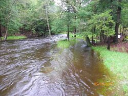
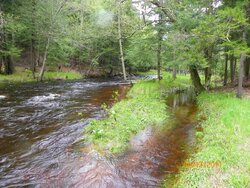
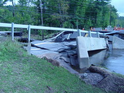
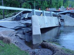
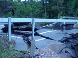
The Brook

  • Active since 1995, Hearth.com is THE place on the internet for free information and advice about wood stoves, pellet stoves and other energy saving equipment.

    We strive to provide opinions, articles, discussions and history related to Hearth Products and in a more general sense, energy issues.

    We promote the EFFICIENT, RESPONSIBLE, CLEAN and SAFE use of all fuels, whether renewable or fossil.
Status
Not open for further replies.

thewoodlands

Minister of Fire
Aug 25, 2009
16,667
In The Woods
The first picture is from the other day right after the heavy rain and the second picture is the same spot but today which is down 1.5 - 2 feet.


Zap
 

Attachments

  • 100_2984.jpg
    100_2984.jpg
    80.9 KB · Views: 396
  • 100_3001.jpg
    100_3001.jpg
    188.5 KB · Views: 379

Attachments

  • DSC01203.jpg
    DSC01203.jpg
    54 KB · Views: 350
  • DSC01204.jpg
    DSC01204.jpg
    55.1 KB · Views: 341
  • DSC01206.jpg
    DSC01206.jpg
    53.8 KB · Views: 338
  • DSC01207.jpg
    DSC01207.jpg
    59.9 KB · Views: 349
  • DSC01208.jpg
    DSC01208.jpg
    53.9 KB · Views: 333
This has been a wet spring (8 or more inches of precip over where we should be for this time of year) but nothing like June 2008. We had major flooding and a lot of bridges were taken out like Zap's pic. That Friday night it rained, as hard as I've ever heard it rain, for about 10 hours. We ended up with about 11 inches of rain that night. The next day it was mass flooding. I was driving through a parking lot at a strip mall...before I knew it the water went from just over the tires on my Ranger to up over the hood when I tried turning around to get out of there. Interstate 70 was shut down because water was flowing over...people being rescued from homes in boats...a lot like what's going on down south now (but in a much smaller area).

That was a wild week. Thankfully my house was high and dry, but many weren't so lucky.

My parents have a creek that runs through their property. I've seen it rise 14' in 24 hours...and then drop just as quickly. Goes from a foot deep to 15' in a hurry. Not uncommon to see 30" + trees floating down the creek when it really gets high.
 
guess there aint a whole lot of fishing on the Ausable when its that high!! holy cow thats a lot of water!! is that on 86 over by the ski center?
 
This has been one of our wettest springs on record... record mountain snowpack (the driest river basin in the state is currently at 138% of normal snowpack), combined with colder than normal spring temps, which have resulted in runoff hardly even starting above 8,000 ft., & an unusually rainy sping have all combined to produce... you guessed it.. record flooding.

I-90 is closed between Hardin, Mt & the Wyoming state line due to the Little Bighorn River flooding, & water is going over the spillway at a dam up by my parent's place in central Mt for the first time since the dam was built nearly 40 years ago... & it's only gonna get worse (more & more rain in the forcast, plus a ton of snow still waiting to come down from the mountains).
 
f3cbboy said:
guess there aint a whole lot of fishing on the Ausable when its that high!! holy cow thats a lot of water!! is that on 86 over by the ski center?


I'm not even sure, I'll find out tonight.


Zap
 
That is the section of the ausable where I always fish. This is going to be tough on the local economy that thrives on summer fishing, as well as skiing in the winter. Wasn't rt 86 closed for a couple of months about 3 yrs ago due to a section being washed out. The section was by the wall past wilmington notch campground if yo were headin south.
 
Status
Not open for further replies.