I get to preview your weather, it hits here first. I would gladly send gmule some of our excess from last week.
Ya, you got nailed, how much rain did you get in your area?
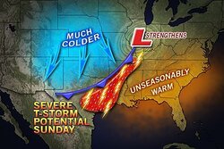
We have this moving in tonight, snow I'll take but the ice could make it tricky.
THE NATIONAL WEATHER SERVICE IN BURLINGTON HAS ISSUED A WINTER
WEATHER ADVISORY FOR MIXED WINTRY PRECIPITATION...WHICH IS IN
EFFECT FROM 10 PM THIS EVENING TO 7 AM EST MONDAY.
* LOCATIONS...CHAMPLAIN VALLEY WEST INTO THE SAINT LAWRENCE VALLEY
AND ADIRONDACKS OF NORTHERN NEW YORK.
* HAZARD TYPES...SNOW...SLEET AND FREEZING RAIN.
* ACCUMULATIONS...SNOW AND SLEET ACCUMULATION OF 1 TO 2 INCHES.
ICE ACCUMULATION A TRACE UP TO A TENTH OF AN INCH...ESPECIALLY
IN NORTHERN NEW YORK.
* TIMING...LATE EVENING SUNDAY THROUGH EARLY MONDAY MORNING.
* IMPACTS...SLICK ROADWAYS DUE TO SNOW AND SLEET. SOME POWER LINES
AND SMALL BRANCHES MAY COME DOWN IN AREAS AWAY FROM THE
CHAMPLAIN VALLEY.
* WINDS...SOUTHEAST 5 TO 15 MPH WITH GUSTS UP TO 30 MPH.
* TEMPERATURES...LOWS AROUND 30...RISING ABOVE FREEZING DURING
MONDAY MORNING.
* VISIBILITIES...1 MILE OR LESS AT TIMES IN SNOW AND SLEET.


") It wasnt fun splitting Friday & Saturday,but burns better than I thought.
It wasnt fun splitting Friday & Saturday,but burns better than I thought.