
Welcome spring?????
- Thread starter GAMMA RAY
- Start date
-
Active since 1995, Hearth.com is THE place on the internet for free information and advice about wood stoves, pellet stoves and other energy saving equipment.
We strive to provide opinions, articles, discussions and history related to Hearth Products and in a more general sense, energy issues.
We promote the EFFICIENT, RESPONSIBLE, CLEAN and SAFE use of all fuels, whether renewable or fossil. -
Super Cedar firestarters 30% discount Use code Hearth2024 Click here
You are using an out of date browser. It may not display this or other websites correctly.
You should upgrade or use an alternative browser.
You should upgrade or use an alternative browser.
- Status
- Not open for further replies.
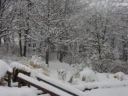
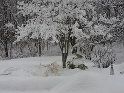
GAMMA RAY said:but isn't it purdy? Got a lot more here in Nepa than they thought...it's like a freakin winter wonderland here....gettin sleet now
Gamma Ray, please keep all the snow south of the Adirondacks. We usually get our last blast of winter in April. :zip: It does look nice.
Zap
We had some in the yard still and got a couple inches more. Should melt pretty quick now though (getting more tomorrow)
That has to be a picture from Alaska lol ")
Looks like a wet snow, shouldn't last long,
but sure takes the wind out of your sails for spring fever.
Hopefully the last one for a while.
Nice pics
Looks like a wet snow, shouldn't last long,
but sure takes the wind out of your sails for spring fever.
Hopefully the last one for a while.
Nice pics
Looks like that could have been taken here. Trouble is, we also got a bunch of freezing rain after the snow and that really made it difficult to push around, but we got it done anyway.
Took off from work yesterday to get in one "final" ride . . . while we had a dusting of snow where I live, in one place where we were riding there was 8-10 inches of fresh snow . . . thinking about playing hookey from work sometime next week to do one "final" ride on the sled . . . finally broke the 1,000 mile mark this year . . . sadly I was hoping to see the abandoned steam locomotives in the woods above Chesuncook Lake . . . but one guy's sled broke down . . .
Mt Ski Bum
Minister of Fire
we still have about 6 feet of snow on the ground around here (7,500 ft.)... about 10 ft. up higher around 11,000 ft. ...
Mt Ski Bum said:we still have about 6 feet of snow on the ground around here (7,500 ft.)... about 10 ft. up higher around 11,000 ft. ...
HehHeh . . . I believe it . . . many years ago my wife and I went from Red Lodge to Cooke City via the Beartooth Scenic Highway in mid-June . . . I still remember a few of the snowbank cutthroughs that the plow had made through and how the snow was still several feet high even in summer.
Mt Ski Bum
Minister of Fire
firefighterjake said:Mt Ski Bum said:we still have about 6 feet of snow on the ground around here (7,500 ft.)... about 10 ft. up higher around 11,000 ft. ...
HehHeh . . . I believe it . . . many years ago my wife and I went from Red Lodge to Cooke City via the Beartooth Scenic Highway in mid-June . . . I still remember a few of the snowbank cutthroughs that the plow had made through and how the snow was still several feet high even in summer.
I love that highway... one of the most scenic drives around. As for those snow banks, there's a reason that there's a summer ski hill (open from approx. Memorial day through early July) up near the summit of the pass! ;-P
Mt Ski Bum
Minister of Fire
Backwoods Savage said:You can keep that 6' of snow out there, please.
Really? I thought I heard that you guys over there in Michigan would love some more snow!

grilling in one inch of melting snow as I post, so much for the april fools storm we got friday, 3 wet sloppy inches.
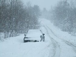
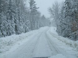
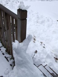
8-10 inches on Friday . . . here's a few pics of my drive home . . . and my sitting snowman and my snow cat attempting to catch a snowbird . . . snow is melting quickly though.
Attachments
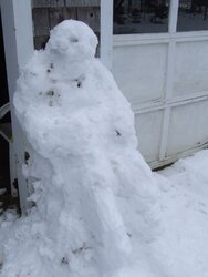
GAMMA RAY said:Its beautiful ffjake..love the workmanship on the snowmen...you are talented...
More stir crazy from the long winter than talented I would say . . . .
Mt Ski Bum
Minister of Fire
Old Man Winter isn't quite done with Montana yet.... 10-20 inches of snow by this weekend:
National Weather Service said:THE NATIONAL WEATHER SERVICE IN GREAT FALLS HAS ISSUED A WINTER STORM WARNING FOR ELEVATIONS ABOVE 6500 FEET FOR HEAVY SNOW...WHICH IS IN EFFECT FROM 6 PM THIS EVENING TO 6 PM MDT FRIDAY. A WINTER WEATHER ADVISORY HAS ALSO BEEN ISSUED. THIS WINTER WEATHER ADVISORY FOR SNOW IS ALSO IN EFFECT FROM 6 PM THIS EVENING TO 6 PM MDT FRIDAY.
* TIMING AND MAIN IMPACT: SNOW SHOWERS WILL BEGIN THIS EVENING AND INCREASE IN INTENSITY THROUGH TONIGHT. STEADIER AND MORE WIDESPREAD SNOW WILL DEVELOP ON THURSDAY WITH SNOW HEAVY AT TIMES IN THE MOUNTAINS. SNOW WILL BEGIN TO DIMINISH LATE FRIDAY.
* SNOW ACCUMULATIONS: STORM TOTAL SNOW ACCUMULATIONS OF 10 TO 20 INCHES ARE EXPECTED IN THE MOUNTAINS ABOVE 6500 FEET WITH 3 TO 5 INCHES OF SNOW BY FRIDAY AFTERNOON AT ELEVATIONS BELOW 6500 FEET.
* WINDS AND VISIBILITY: SOUTHWEST WINDS AT 10 TO 20 MPH TONIGHT WILL SHIFT TO NORTHEAST ON THURSDAY AND INCREASE TO 15 TO 25 MPH THURSDAY NIGHT INTO FRIDAY. THIS WILL CAUSE REDUCED VISIBILITIES IN BLOWING AND DRIFTING SNOW...ESPECIALLY OVER MOUNTAIN PASSES.
* OTHER IMPACTS: WET AND COLD CONDITIONS WILL STRESS YOUNG LIVESTOCK AND HEAVY WET SNOW MAY ADD CONSIDERABLE WEIGHT TO TREES AND POWER LINES.
* LOCATIONS AFFECTED INCLUDE: WHITE SULPHUR SPRINGS...BATTLE RIDGE PASS...BOZEMAN...BOZEMAN PASS...TARGHEE PASS...WEST YELLOWSTONE...BIG HOLE PASS...CHIEF JOSEPH PASS...DILLON... MONIDA PASS...ENNIS...NORRIS HILL...RAYNOLDS PASS...TWIN BRIDGES.
Winter Weather Advisory
NYZ019>021-070300-
/O.NEW.KBUF.WW.Y.0016.110406T2139Z-110407T0300Z/
CHAUTAUQUA-CATTARAUGUS-ALLEGANY-
INCLUDING THE CITIES OF…JAMESTOWN…OLEAN…WELLSVILLE
539 PM EDT WED APR 6 2011
...WINTER WEATHER ADVISORY IN EFFECT UNTIL 11 PM EDT THIS
EVENING…
THE NATIONAL WEATHER SERVICE IN BUFFALO HAS ISSUED A WINTER
WEATHER ADVISORY FOR SNOW…WHICH IS IN EFFECT UNTIL 11 PM EDT THIS
EVENING.
* LOCATIONS…THE WESTERN SOUTHERN TIER…PARTICULARLY ACROSS THE
HIGHER TERRAIN.
* TIMING…UNTIL LATE THIS EVENING.
* HAZARDS…HEAVY WET SNOW…MIXED WITH RAIN AT TIMES ACROSS THE
LOWER ELEVATIONS.
* ACCUMULATIONS…ADDITIONAL ACCUMULATIONS OF 4 TO 6 INCHES…WITH
THE HIGHEST AMOUNTS ACROSS THE HIGHER TERRAIN. THIS WILL RESULT
IN TOTAL SNOWFALL ACCUMULATIONS OF 7 TO 12 INCHES…WITH THE
HIGHEST AMOUNTS AGAIN FOUND ACROSS THE HIGHER TERRAIN.
* VISIBILITIES…AS LOW AS ONE QUARTER MILE AT TIMES.
* IMPACTS…THE SNOW WILL PRODUCE GREATLY REDUCED VISIBILITIES AND
SLIPPERY SNOW COVERED CONDITIONS ON UNTREATED ROADWAYS…
ESPECIALLY ACROSS THE HIGHER TERRAIN. THE HEAVY WET NATURE OF
THE SNOW WILL ALSO HELP TO WEIGH DOWN TREE BRANCHES AND POWER
LINES…AND MAY LEAD TO SOME ISOLATED POWER OUTAGES.
PRECAUTIONARY/PREPAREDNESS ACTIONS…
Mt Ski Bum
Minister of Fire
PapaDave said:I think I'd move. FEET of snow?!! Um, ....no thanks.
Great for skiing! Plus, I'm used to it- I've never lived any but Montana. It's not that unusual for us to have a storm dump +6" on us in June before.
- Status
- Not open for further replies.
Similar threads
- Replies
- 5
- Views
- 257
- Replies
- 7
- Views
- 1K
- Replies
- 13
- Views
- 893
- Replies
- 1
- Views
- 341
- Replies
- 5
- Views
- 397