I used my snowblower a couple times. I was fighting a pinched nerve and didn’t want to shovel too much for most of the winter. All the snow we got was pretty much wet and heavy.
2024 severe weather!
- Thread starter EatenByLimestone
- Start date
-
Active since 1995, Hearth.com is THE place on the internet for free information and advice about wood stoves, pellet stoves and other energy saving equipment.
We strive to provide opinions, articles, discussions and history related to Hearth Products and in a more general sense, energy issues.
We promote the EFFICIENT, RESPONSIBLE, CLEAN and SAFE use of all fuels, whether renewable or fossil.
You are using an out of date browser. It may not display this or other websites correctly.
You should upgrade or use an alternative browser.
You should upgrade or use an alternative browser.
Latest forecast shows 8-12”overnight. Truck is up by the road, I don’t want to get stuck away from it. Wood is moved in so I should have enough to tide me until Sunday.
thewoodlands
Minister of Fire
I made sure everything was fueled up, at the moment we're not getting much but that should change overnight.Latest forecast shows 8-12”overnight. Truck is up by the road, I don’t want to get stuck away from it. Wood is moved in so I should have enough to tide me until Sunday.
I did get the old 028 Wood Boss out, it started right up so I sharpened three chains for it. I haven't run that in over a year.
bogieb
Minister of Fire
I'm in for anywhere from 4-12", or maybe even more depending on what source I look at. Then a couple of hours of sleet/rain, then possibly more snow as the storm wraps around after dark tonight.


thewoodlands
Minister of Fire
Sounds like a big mess if you get what they're calling for. We didn't get much snow overnight but it's starting to pickup this morning.I'm in for anywhere from 4-12", or maybe even more depending on what source I look at. Then a couple of hours of sleet/rain, then possibly more snow as the storm wraps around after dark tonight.
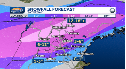
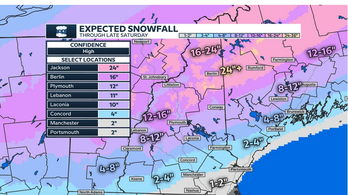
View attachment 326052View attachment 326053View attachment 326054
peakbagger
Minister of Fire
I am sitting next the a 24" (berlin) on the lower graphic. as of 7 AM I have about 1/2" of snow, I was expected more when I got up. No doubt I will get more but these predicted snow totals are looking like a ski industry late season hype event. When the media wants to crank up the totals, they start listing the snow totals at high elevations like a ski area.
The frost is coming out of the ground so the snow tends to melt quicker once we have a sunny day. Probably not a good day for any solar generation but when the sun comes out tomorrow, once I clean the panels it will could be a record day as the fresh snow reflects additional sun on the panels. . It comes down to if clears out before sunrise so I generate all day.
The frost is coming out of the ground so the snow tends to melt quicker once we have a sunny day. Probably not a good day for any solar generation but when the sun comes out tomorrow, once I clean the panels it will could be a record day as the fresh snow reflects additional sun on the panels. . It comes down to if clears out before sunrise so I generate all day.
Lots of sugar snow falling now. 23F outside. It looks like they were right when they guessed around 6”.
DonTee
Minister of Fire
We got around 6” here also. It’s still snowing right now but is supposed to be done around noon they say. Then it will warm up next week. Tonight is the last cooler night they call for that I can see in the 10 day forecast. Low of 16 degrees.
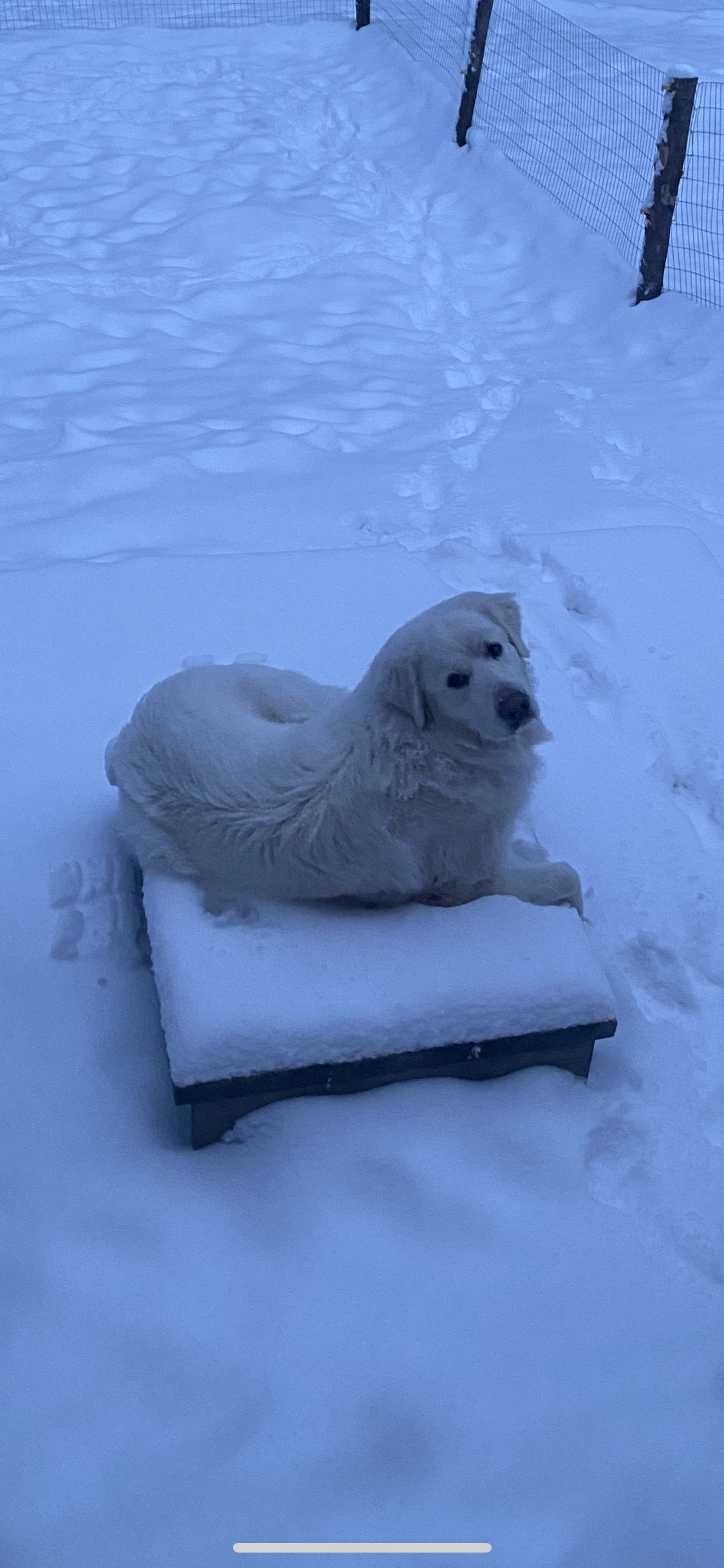
My Pyrenees loves the snow. She was excited when she went outside this morning.

My Pyrenees loves the snow. She was excited when she went outside this morning.
thewoodlands
Minister of Fire
We're getting the sugar snow too, about 4 inches so far. We have two more nights of cooler temps 12 & 14 and then the warmer weather with rains move in next week.
joop
Minister of Fire
thewoodlands
Minister of Fire
joop
Minister of Fire
bogieb
Minister of Fire
I now have about 6" of block ice everywhere. I chose to leave the snow to soak up the sleet/rain, and I may be paying the price for it for a week or more. And the solar panels probably won't generate anything for a couple of days - or longer. Today supposed to get sun, but the rest of the week will be cloudy so they won't heat up.
The one good decision I made yesterday was to have a neighbor blow out the berm at the end of the driveway last night with his plow truck. First time I've ever paid anyone to take care of any snow event since I've been here.
The one good decision I made yesterday was to have a neighbor blow out the berm at the end of the driveway last night with his plow truck. First time I've ever paid anyone to take care of any snow event since I've been here.
thewoodlands
Minister of Fire
johneh
Minister of Fire
Ottawa Ontario Wednesday and Thursday
5:59 PM EDT Monday 1 April 2024
Early spring storm expected to bring rain and the potential for significant snow Wednesday through Thursday night.Discussion:A Colorado low is expected to begin affecting the region Wednesday morning. Precipitation is expected to begin as rain transitioning to snow late Wednesday afternoon or early evening. Snow, which may be heavy at times, is expected to continue through Wednesday night easing Thursday night. Significant snowfall accumulations are possible by the time snow begins to ease Thursday night. Impacts ower outages will be possible. Travel may become hazardous due to accumulating snow and reduced visibility.Confidence is low as there remains a high degree of uncertainty with the low's track, which will have significant impacts on temperatures, snowfall amounts as well as when rain will transition to snow. Warnings, if required, will be issued as the event draws nearer.Please continue to monitor alerts and forecasts issued by Environment Canada. To report severe weather, send an email to [email protected] or tweet reports using #ONStorm.
Follow:
5:59 PM EDT Monday 1 April 2024
Early spring storm expected to bring rain and the potential for significant snow Wednesday through Thursday night.Discussion:A Colorado low is expected to begin affecting the region Wednesday morning. Precipitation is expected to begin as rain transitioning to snow late Wednesday afternoon or early evening. Snow, which may be heavy at times, is expected to continue through Wednesday night easing Thursday night. Significant snowfall accumulations are possible by the time snow begins to ease Thursday night. Impacts
 ower outages will be possible. Travel may become hazardous due to accumulating snow and reduced visibility.Confidence is low as there remains a high degree of uncertainty with the low's track, which will have significant impacts on temperatures, snowfall amounts as well as when rain will transition to snow. Warnings, if required, will be issued as the event draws nearer.Please continue to monitor alerts and forecasts issued by Environment Canada. To report severe weather, send an email to [email protected] or tweet reports using #ONStorm.
Follow:
bogieb
Minister of Fire
Depending on who is forecasting, I'm in the 12-24" range for snow from the imminent Nor'easter. The wind expected is going to be the main issue and I expect power outages will again be a major issue as it was from the storm 10 days ago.
joop
Minister of Fire
thewoodlands
Minister of Fire
They say the worst of it starts around 11 a.m. tomorrow morning over in this area, what time does it hit your area once it clears the border?nah,according to woodlands map it stops right at the border,lucky us
joop
Minister of Fire
johneh
Minister of Fire
Now forecasting 20 to 30 cm here (8 to 12 in.)
by Thursday afternoon starting tonight and
then temp in the teen by Saturday (55 to62)
What a mixed up screwed up world we live in
by Thursday afternoon starting tonight and
then temp in the teen by Saturday (55 to62)
What a mixed up screwed up world we live in
thewoodlands
Minister of Fire
We're about the same, NOAA keeps on dropping the snow totals, 4 to 6 the last I looked.15cm but tonight
stoveliker
Minister of Fire
Here it's just pouring for a second day, now with strong winds.
Around 40 F out, 69 F inside from the mini split
Around 40 F out, 69 F inside from the mini split
joop
Minister of Fire
johneh
Minister of Fire
Similar threads
- Replies
- 5
- Views
- 1K
- Replies
- 1
- Views
- 690
- Replies
- 16
- Views
- 672

