
Looks like the woodlands might be off limits for another week and so will cutting the cherry up front, plan C might include dropping the barkless & dead Sugar Maple just off the path going to the wood stacks.
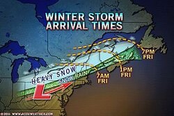
...WINTER STORM WARNING REMAINS IN EFFECT FROM 4 AM TO 11 PM EST FRIDAY...
THE NATIONAL WEATHER SERVICE IN BURLINGTON CONTINUES THE WINTER STORM WARNING...FROM 4 AM TO 11 PM EST FRIDAY.
* LOCATIONS...ALL OF SOUTH-CENTRAL...CENTRAL AND NORTHERN VERMONT. THE NORTHERN ADIRONDACKS AND CHAMPLAIN VALLEY OF NEW YORK.
* HAZARD TYPES...HEAVY SNOW AND BLOWING SNOW. SNOW MAY MIX WITH SLEET ACROSS SOUTH-CENTRAL VERMONT.
* ACCUMULATIONS...6 TO 12 INCHES OF SNOW...FALLING AT A RATE OF 1-2 INCHES PER HOUR.
* TIMING...SNOW WILL BEGIN BY THE PRE-DAWN HOURS FRIDAY...THEN FALL HEAVY AT TIMES THROUGHOUT THE DAY. SNOW WILL TAPER OFF FRIDAY EVENING. STRONG NORTH WINDS WILL BRING BLOWING AND DRIFTING SNOW FRIDAY AFTERNOON THROUGH MIDNIGHT FRIDAY NIGHT.
* IMPACTS...DIFFICULT TRAVEL DUE TO SNOW COVERED ROADWAYS AND VERY LOW VISIBILITY IN SNOW AND BLOWING SNOW.
* WINDS...NORTH INCREASING TO 20 TO 30 MPH WITH GUSTS UP TO 40 MPH FRIDAY AFTERNOON AND EVENING.
* TEMPERATURES...IN THE UPPER 20S TO LOWER 30S.
* VISIBILITIES...NEAR ZERO AT TIMES IN HEAVY SNOW AND BLOWING SNOW.
PRECAUTIONARY/PREPAREDNESS ACTIONS...
A WINTER STORM WARNING FOR HEAVY SNOW MEANS SEVERE WINTER WEATHER CONDITIONS ARE EXPECTED OR OCCURRING. SIGNIFICANT AMOUNTS OF SNOW ARE FORECAST THAT WILL MAKE TRAVEL DANGEROUS. IF YOU MUST TRAVEL...KEEP AN EXTRA FLASHLIGHT...FOOD...AND WATER IN YOUR VEHICLE IN CASE OF AN EMERGENCY.
PLEASE STAY TUNED TO NOAA WEATHER RADIO...YOUR LOCAL MEDIA...OR GO TO WWW.WEATHER.GOV/BURLINGTON FOR FURTHER UPDATES ON THIS WEATHER SITUATION.
Zap
")